
Favourite
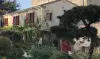
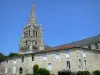
The Commandery and Collegiate Church of Saint-Marc-la-Lande
| Municipality | Cours |
|---|---|
| Postcode | 79220 |
| Latitude | 46.4971780 (N 46° 29’ 50”) |
| Longitude | -0.4131570 (W 0° 24’ 47”) |
| Altitude | From 63m to 169m |
| Surface area | 14.92 km² |
| Population | 576 inhabitants |
| Density | 38 inhabitants/km² |
| Prefecture | Niort (24 km, 28 min) |
| Insee code | 79104 |
| Intercommunality | CC Val de Gâtine |
| Department | Deux-Sèvres |
| Territory | Poitou |
| Region | New-Aquitaine |
| Champdeniers | 3.2 km (5 min) |
|---|---|
| Saint-Marc-la-Lande | 4 km (9 min) |
| Les Groseillers | 4.1 km (6 min) |
| Germond-Rouvre | 5.5 km (10 min) |
| Pamplie | 5.7 km (8 min) |
| Xaintray | 7.8 km (12 min) |
| Sainte-Ouenne | 7.8 km (10 min) |
| La Boissière-en-Gâtine | 8.3 km (16 min) |
| Surin | 8.3 km (12 min) |
| Saint-Christophe-sur-Roc | 9 km (11 min) |
| La Chapelle-Bâton | 9.4 km (13 min) |
| Béceleuf | 10.3 km (12 min) |
| Mazières-en-Gâtine | 10.5 km (14 min) |
| Fenioux | 11.3 km (13 min) |
| Last name | Outing type | Difficulty | Duration | Departure municipality |
|---|---|---|---|---|
 | Hike | Intermediate | 3:45 | Saint-Michel-le-Cloucq (26 km) |
 | Hike | Easy | 1:05 | Le Gué-de-Velluire (41 km) |
 | Hike | Easy | 1:05 | La Taillée (42 km) |
 | Hike | Easy | 1:00 | La Taillée (42 km) |
 | Hike | Easy | 4:55 | Sainte-Radégonde-des-Noyers (51 km) |