


Favourite
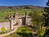
Digoine Castle
| Municipality | Clessy |
|---|---|
| Postcode | 71130 |
| Latitude | 46.5575380 (N 46° 33’ 27”) |
| Longitude | 4.0870939 (E 4° 5’ 14”) |
| Altitude | From 242m to 340m |
| Surface area | 16.99 km² |
| Population | 283 inhabitants |
| Density | 16 inhabitants/km² |
| Prefecture | Mâcon (78 km, 1:10) |
| Insee code | 71136 |
| Intercommunality | CC Entre Arroux, Loire et Somme |
| Department | Saône-et-Loire |
| Territory | Burgundy |
| Region | Burgundy-Franche-Comté |
| Saint-Vincent-Bragny | 5 km (7 min) |
|---|---|
| Chassy | 5.4 km (9 min) |
| Rigny-sur-Arroux | 6.2 km (10 min) |
| Gueugnon | 6.8 km (10 min) |
| Oudry | 7.9 km (12 min) |
| Marly-sur-Arroux | 8.9 km (14 min) |
| Vendenesse-sur-Arroux | 11.1 km (15 min) |
| Curdin | 11.2 km (13 min) |
| Saint-Aubin-en-Charollais | 12.8 km (15 min) |
| Digoin | 13.2 km (19 min) |
| Perrecy-les-Forges | 14.3 km (17 min) |
| La Chapelle-au-Mans | 15.2 km (20 min) |
| Volesvres | 15.4 km (18 min) |
| Génelard | 15.9 km (20 min) |
| Last name | Activity type | Rate | City |
|---|---|---|---|
 | Culture and education | 10 € | Saint-Point (47 km) |
| Last name | Outing type | Difficulty | Duration | Departure municipality |
|---|---|---|---|---|
 | Hike | Intermediate | 3:00 | La Boulaye (21 km) |
 | Hike | Easy | 1:30 | Saint-Eugène (22 km) |
 | Hike | Athletic | 3:00 | Dettey (24 km) |
 | Hike | Athletic | 5:00 | Charbonnat (26 km) |
 | Hike | Easy | 2:00 | Thil-sur-Arroux (27 km) |


