
Favourite
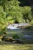
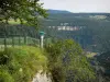
The Consolation rock formations
| Municipality | Charmoille |
|---|---|
| Postcode | 25380 |
| Tourism label | ") |
| Latitude | 47.2463810 (N 47° 14’ 47”) |
| Longitude | 6.6726040 (E 6° 40’ 21”) |
| Altitude | From 460m to 852m |
| Surface area | 10.14 km² |
| Population | 328 inhabitants |
| Density | 32 inhabitants/km² |
| Prefecture | Besançon (64 km, 1:02) |
| Insee code | 25125 |
| Intercommunality | CC du Pays de Sancey-Belleherbe |
| Department | Doubs |
| Territories | Franche-Comté, Jura mountains |
| Region | Burgundy-Franche-Comté |
| Chamesey | 2.4 km (5 min) |
|---|---|
| Belleherbe | 2.5 km (5 min) |
| Vaucluse | 3.7 km (7 min) |
| Longevelle-lès-Russey | 4.2 km (8 min) |
| Bretonvillers | 4.6 km (8 min) |
| La Grange | 4.8 km (9 min) |
| Cour-Saint-Maurice | 5.2 km (10 min) |
| Rosureux | 5.4 km (14 min) |
| Provenchère | 6.1 km (9 min) |
| Surmont | 8.5 km (13 min) |
| Froidevaux | 9 km (16 min) |
| Orgeans-Blanchefontaine | 9.8 km (17 min) |
| Rosières-sur-Barbèche | 10 km (16 min) |
| Valoreille | 10.1 km (15 min) |
| Péseux | 10.2 km (17 min) |
| Last name | Activity type | Rate | City |
|---|---|---|---|
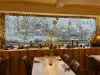
 | Entertainment | 84 € to 110 € | Besançon (49 km) |
| Last name | Outing type | Difficulty | Duration | Departure municipality |
|---|---|---|---|---|
 | Hike | Easy | 1:00 | Pays-de-Clerval (21 km) |
 | Hike | Intermediate | 35 min | Grand-Charmont (32 km) |
 | Hike | Intermediate | 35 min | Hauterive-la-Fresse (35 km) |
 | Hike | Easy | 6:00 | Devecey (50 km) |
 | Hike | Easy | 1:05 | La Rivière-Drugeon (55 km) |