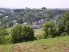
Carlat is a village of Cantal, in the Auvergne-Rhône-Alpes region, 20 km south-east of Aurillac.
The village developed at the foot of a rock born from a lava flow on already basaltic ground, southwest of the Massif Central.
From the eighth century, the strategic location of the rock justifies the erection of a first castle which becomes in the fifteenth century a fortress known as "one of the most formidable citadels of the South of France".
His lord, Viscount Jacques d'Armagnac, also Duke of Nemours, then dominates a so-called impregnable valley but his influence and its conspiracy aims end up displeasing the King of France. Several seats follow one another and Henri IV shaves the castle in 1604.
Sold during the Revolution, the site was turned into a quarry before being acquired at the end of the 19th century by the Prince of Monaco, who still owns it, to prevent it from being completely disfigured. One of his ancestors had, it is true, been a lord of Carlat under the Ancien Régime.
Today populated by about 360 inhabitants, the village wants to reconnect with its prestigious past. Since 2010, Carlat is paired with the Italian hamlet of Bruni to boost tourism communication by playing on the names Carlat and Bruni, referring to the wife of President Sarkozy.
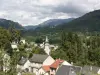
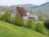
The site of the rock is still the jewel of the city, which has other major heritage elements. In a unique natural environment that delights hikers, Carlat is a great stop for visiting this part of Auvergne.
The rock overlooking Carlat and its valley is still visited. But if there are only ruins of the prestigious enclosure where Marguerite de Valois (Queen Margot) stayed and whose lord defied the kings of France, once on the plateau at 900 m altitude, a modern process allows the tourist to plunge back into the past. Through screens and helmets equipped with an "augmented reality" device, the buildings and events that punctuated the history of the citadel are reconstructed in 3D. Open from May to the end of September. Free or guided tours, with 3D system or code download. Price: 3 to 7 euros. Information on +33 4 71 43 65 08.
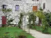
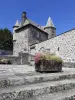
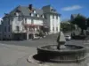
In the village, with the traditional architecture, to visit then, the church Saint-Avit, built from 1503 to 1522 on the initiative of the daughter of Louis XI, viscountess of Carlat. The church was remodeled in 1649, a ceiling replacing the vaults, and the stone pavement was restored in 1845. The interior paintings date from the late nineteenth century. On the other hand, the plan of the building has not been modified since its origin. It has a nave of two unequal bays, extended by a straight choir and a pentagonal apse. Two chapels open on both sides. The vault rests on carved pedestals. A wooden turret containing a spiral staircase rises from the platform to the belfry. Note the beautifully carved portal, and the sculptures and paintings that adorn the whole.
Nearby, in the old cemetery, a 16th century oratory houses an altar and a sculpted Calvary, as well as the tombs of former parish priests. The oratory is made up of four pillars of andesite (gray volcanic rock), with a wooden frame and a lauze roof. The cross is also in andesite.
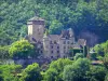
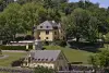
Finally, still on the territory of the commune, the castle of Celles is also classified. It dates from the seventeenth century, consisting of a pavilion covered with lauzes framed by two towers conical roof.
The rock (and the splendid panorama that awaits the visitor), the old castle, the traditional village and all the elements of historical and natural heritage can be included in different hiking routes (walking or mountain biking). Some routes may include incursions into the surrounding countryside and even the north of Aveyron, only a few kilometers away. Attention, circuits can present difficulties related to relief. Documentation and information on +33 4 71 48 46 58.
In this region of volcanic origin, climbing enthusiasts can find their happiness. For introductory sessions or courses reserved for seasoned athletes, call +33 4 71 62 47 65.
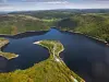
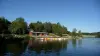
Finally, the rivers that cross the territory are good playgrounds for fishermen. Information on adapted sites and regulations at +33 4 71 48 19 25.
May 1st, bread festival.
The third weekend of July, village festival with fun, musical and gourmet entertainment.
Wednesday evening from mid-July to mid-August, country market.