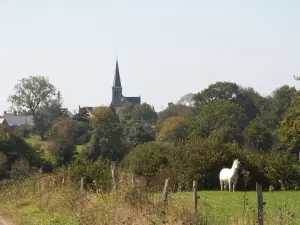
- Church of St. John the Baptist:
- It was built in 1883 and has the shape of a Latin cross through the addition of two chapels. It is a beautiful Romanesque building transitional Gothic. A large granite staircase provides access to the central door. Note the cross, the altar, the pulpit and the wrought iron railing that is unique.
- Open house on Saturday from 9h to 19h.
- Town Hall:
- It is one of the oldest houses in the town and still retains a very old device to heat the dishes called "the garden", rare in Mayenne. It has the right and left of the top two excavations with cast iron grates to hold the coals while the ash slide along the bottom of both sides medians.
- Visible opening hours of the town hall. Next to the church.
- Cross and epigraphs:
- Many epigraphs found on the walls of the old school where 80 inmates were housed. Note also a block built into the dwelling house of the village of Lower Bourg. It has a granite in the heart reversed, a cooper's ax is equivalent to a signature and four symbolic tears.
- The cross cémétériale, early 16th century, is transferred to the new cemetery in the late nineteenth century. This cross is based on a pyramidal base truncated, adorned with four carved heads at the corners. On leaving the village, the road Tannière.