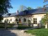
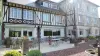
The church of Saint-Sauveur is flint and sandstone portal of the Renaissance in the 16th century.


Favourite
| Municipality | Bouvresse |
|---|---|
| Postcode | 60220 |
| Latitude | 49.6545730 (N 49° 39’ 16”) |
| Longitude | 1.7533020 (E 1° 45’ 12”) |
| Altitude | From 211m to 226m |
| Surface area | 2.80 km² |
| Population | 163 inhabitants |
| Density | 58 inhabitants/km² |
| Prefecture | Beauvais (38 km, 42 min) |
| Insee code | 60098 |
| Intercommunality | CC de la Picardie Verte |
| Department | Oise |
| Territory | Picardy |
| Region | Hauts-de-France |
| Formerie | 2.4 km (4 min) |
|---|---|
| Blargies | 2.5 km (4 min) |
| Monceaux-l'Abbaye | 3 km (5 min) |
| Mureaumont | 3.9 km (6 min) |
| Campeaux | 4.1 km (7 min) |
| Moliens | 4.9 km (8 min) |
| Abancourt | 5 km (6 min) |
| Criquiers | 6.3 km (10 min) |
| Broquiers | 7.1 km (8 min) |
| Feuquières | 7.2 km (8 min) |
| Saint-Arnoult | 7.6 km (10 min) |
| Lannoy-Cuillère | 8 km (12 min) |
| Haucourt | 8 km (12 min) |
| Grumesnil | 8.4 km (13 min) |
The church of Saint-Sauveur is flint and sandstone portal of the Renaissance in the 16th century.
| Last name | Activity type | Rate | City |
|---|---|---|---|
 | Nature and the great outdoors | 12 € to 16 € | Saint-Denis-sur-Scie (45 km) |
| Last name | Outing type | Difficulty | Duration | Departure municipality |
|---|---|---|---|---|
 | Hike | Easy | 35 min | Forges-les-Eaux (15.6 km) |
 | Cycling itinerary | Athletic | 2:45 | Forges-les-Eaux (16.5 km) |
 | Car itinerary | Easy | 1:05 | Forges-les-Eaux (16.8 km) |
 | Hike | Easy | 50 min | Gournay-en-Bray (19.1 km) |
 | Hike | Easy | 1:30 | Saint-Léger-aux-Bois (22 km) |