- The Campaines, amusement park for children, Accolans (2 km).
- Pony club to Courchaton (8 km).
- Canoeing in Villersexel (13 km).
- Abbey Marast twelfth century (15 km).
- Lake Bonnal, swimming (17 km).
- Swingolf and ropes to Montenois (18 km).


Favourite


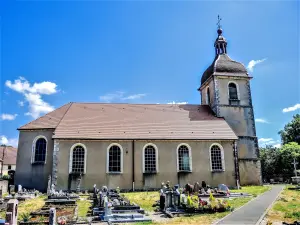
| Municipality | Bournois |
|---|---|
| Postcode | 25250 |
| Latitude | 47.4986880 (N 47° 29’ 55”) |
| Longitude | 6.4960220 (E 6° 29’ 46”) |
| Altitude | From 330m to 521m |
| Surface area | 10.48 km² |
| Population | 192 inhabitants |
| Density | 18 inhabitants/km² |
| Prefecture | Besançon (65 km, 56 min) |
| Insee code | 25083 |
| Intercommunality | CC des Deux Vallées Vertes |
| Department | Doubs |
| Territories | Franche-Comté, Jura mountains |
| Region | Burgundy-Franche-Comté |
| Fallon | 2.7 km (5 min) |
|---|---|
| Mélecey | 4.1 km (7 min) |
| Accolans | 4.4 km (8 min) |
| Abbenans | 4.9 km (7 min) |
| Grammont | 6.3 km (9 min) |
| Soye | 6.4 km (11 min) |
| Georfans | 6.6 km (10 min) |
| Villargent | 6.7 km (11 min) |
| Les Magny | 7 km (11 min) |
| Saint-Ferjeux | 7.6 km (13 min) |
| Geney | 8.6 km (16 min) |
| Courchaton | 8.6 km (14 min) |
| Cubry | 8.7 km (14 min) |
| Cubrial | 8.9 km (13 min) |
| Leisure centres |
|---|

| Last name | Activity type | Rate | City |
|---|---|---|---|
 | Entertainment | 84 € to 110 € | Besançon (46 km) |
 | Culture and education | 11 € | Le Thillot (46 km) |
| Last name | Outing type | Difficulty | Duration | Departure municipality |
|---|---|---|---|---|
 | Hike | Easy | 1:00 | Pays-de-Clerval (11.7 km) |
 | Hike | Intermediate | 35 min | Grand-Charmont (25 km) |
 | Hike | Easy | 1:05 | Ferrières-lès-Scey (40 km) |
 | Hike | Easy | 6:00 | Devecey (41 km) |
 | Hike | Athletic | 5:05 | Fretigney-et-Velloreille (41 km) |


