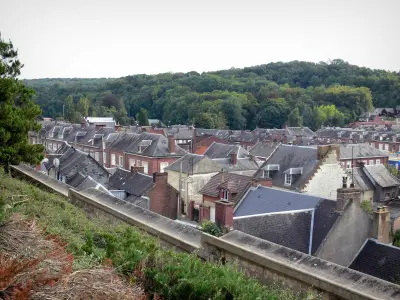
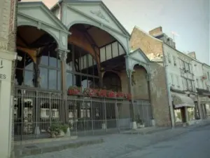
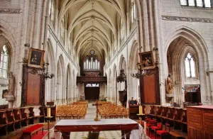
Charming Norman town of nearly 2,000 inhabitants in Upper Normandy, nestled in the hollow of the Bresle valley, 75 km east of Rouen, 45 km west of Amiens (exit 12 on the A29), 120 km north-west of Paris, 45 km south of Le Tréport.


Favourite


Charming Norman town of nearly 2,000 inhabitants in Upper Normandy, nestled in the hollow of the Bresle valley, 75 km east of Rouen, 45 km west of Amiens (exit 12 on the A29), 120 km north-west of Paris, 45 km south of Le Tréport.
| Municipality | Aumale |
|---|---|
| Postcode | 76390 |
| Tourism labels |  ") |
| Latitude | 49.7686100 (N 49° 46’ 7”) |
| Longitude | 1.7521190 (E 1° 45’ 8”) |
| Altitude | From 106m to 212m |
| Surface area | 9.06 km² |
| Population | 2014 inhabitants |
| Density | 222 inhabitants/km² |
| Prefecture | Rouen (76 km, 49 min) |
| Insee code | 76035 |
| Intercommunality | CC interrégionale Aumale - Blangy-sur-Bresle |
| Department | Seine-Maritime |
| Region | Normandy |
| Quincampoix-Fleuzy | 3.2 km (6 min) |
|---|---|
| Gauville | 3.8 km (7 min) |
| Haudricourt | 5.4 km (8 min) |
| Morienne | 5.4 km (8 min) |
| Marques | 6.1 km (7 min) |
| Gourchelles | 6.2 km (10 min) |
| Saint-Valery | 6.5 km (13 min) |
| Ellecourt | 6.6 km (9 min) |
| Morvillers-Saint-Saturnin | 6.7 km (8 min) |
| Beaucamps-le-Jeune | 6.8 km (11 min) |
| Fourcigny | 7.1 km (10 min) |
| Lannoy-Cuillère | 7.9 km (12 min) |
| Lafresguimont-Saint-Martin | 7.9 km (14 min) |
| Escles-Saint-Pierre | 8.3 km (11 min) |
| Information points | |
|---|---|
| Transport |
For more details, see the website of the city of Aumale / agenda.


Horse riding at 4 km and 7 km.
| Last name | Activity type | Rate | City |
|---|---|---|---|
 | Nature and the great outdoors | 12 € to 16 € | Saint-Denis-sur-Scie (46 km) |
 | Nature and the great outdoors | 10 € to 18 € | Saint-Valery-sur-Somme (46 km) |
 | Sports sensations | 45 € to 105 € | Saint-Valery-sur-Somme (48 km) |
 | Nature and the great outdoors | 39 € | Saint-Valery-sur-Somme (48 km) |
| Last name | Outing type | Difficulty | Duration | Departure municipality |
|---|---|---|---|---|
 | Hike | Easy | 1:30 | Saint-Léger-aux-Bois (12.4 km) |
 | Hike | Easy | 2:30 | Saint-Léger-aux-Bois (12.5 km) |
 | Hike | Easy | 2:15 | Aubermesnil-aux-Érables (14.7 km) |
 | Hike | Easy | 1:15 | Aubermesnil-aux-Érables (14.7 km) |
 | Village visit | Easy | 2:00 | Saint-Maulvis (16.4 km) |