Apprieu is a town in Isère, in the Auvergne-Rhône-Alpes region, 10 km northwest of Voiron.
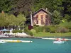
Its 15 km² territory ranges from 371 to 773 m in altitude, belonging to the eastern part of the Bièvre plain, announcing the Alpine massif to the east. It has retained a verdant character, covered for 46% of its surface area with forests and 40% with agricultural land.
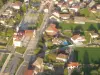
In the second half of the 20th century, located between the Lyon and Grenoble conurbations, served by the motorway, Apprieu experienced economic (new industrial establishments) and demographic development.
However, from the 16th century, the city had acquired a certain notoriety thanks to the forges of Bonpertuis, a tradition of steel production which has remained alive until today. It is in the small town of 3300 inhabitants that the corkscrew of the Swiss army knives is still manufactured!
With an interesting cultural and "nature" leisure offer, Apprieu is worth a detour between Dauphiné and the Rhône Valley...
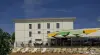
In terms of heritage, if the parish church of Saint-Pierre, which has preserved Romanesque foundations, can be the starting point for a discovery tour, it is the forges of Bonpertuis that are the major historical site. They were created in 1434, near the course of La Fure, in the south of the territory. The know-how is then inherited from the Carthusian monks. According to local history, it was here that the sword of François I was forged before the battle of Marignan. In fact, it was after the Italian wars that steel production intensified thanks to Jehan Perron in 1574. This know-how was perpetuated over the centuries and in the 19th century, new manufacturing methods were adopted. steel. In 1859, they were based on English-style foundries with coke-heated ovens, rolling mills and carburizing furnaces. After the First World War, electric arc furnaces were installed. Today, still modernized, the industrial site employs more than 100 people and production is exported to 50 countries. In the meantime, one of the ovens established by Alphonse Gourju in 1859 has been listed in the Inventory. Built in brick, it consists of a quadrangular base 10 m high, reinforced around its perimeter with vertically fixed iron bars. It is surmounted by a conical chimney 5 m in diameter and 10 m high. It is the last oven of this type preserved in France. As the Aciéries de Bonpertuis site is still in operation, it is only open to the public very occasionally. Inquire on +33 4 76 65 15 15.
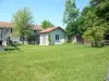
In another register, in addition to some heritage elements typical of rural towns that have become small towns (old washhouses, fountains, etc.), it is still in the south of the municipal territory that the e can see two works of art: a viaduct dating from 1860 spanning the Fure to allow the passage of the railway line linking Lyon to Grenoble. 263 m long, with 16 arches, the viaduct overlooks the river 45 m high.
More recently, built this time in concrete, a second viaduct was erected when the motorway between Lyon and Grenoble was built.
On the cultural side, in addition to regular activities (meetings, readings), the town's media library hosts each year, as well as the town hall, four artistic exhibitions (one per season), dedicated to painters, sculptors or photographers and, in summer, to local "amateur" artists. Inquire on +33 4 76 65 10 13 or +33 4 76 35 38 84.
On the sports side, the large municipal complex is accessible to visitors and holidaymakers and includes tennis courts, football pitches or volleyball courts, a bowling alley… Information on +33 4 76 65 10 13.
Still largely wooded, dominated to the north by Mont Follet which culminates at 773 m and bordered to the south by the Fure river, the territory is finally suitable for hiking. It is thus possible to join the outings offered by the Nordic walking and health club (contact +33 6 72 13 97 44). Marked circuits open for some on two-wheelers are also available, including incursions into neighboring localities. Without forgetting larger routes allowing to join Voiron and other sites of the Country of the plain of Bièvre. Maps and information on +33 4 76 06 10 94 or +33 4 76 93 17 60.