Altier is a commune in the Lozère department, in the Occitanie region, 11 km northwest of Villefort (by road).
Vast of 54 km², its territory ranges from 616 to 1678 m above sea level. It covers the “northern” slope of Mont Lozère (which corresponds to the “southern” half of the locality) and the “southern” slope of the Goulet mountain (“northern” half), culminating near Pic Cassini to the south. -East.
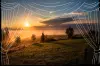
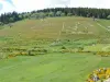
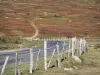
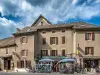
From west to east, the course of the a Mediterranean climate except in winter when temperatures are harsh, Altier is made up of a town and several villages or hamlets. Dotted with areas protected for their biodiversity, the locality is covered with forests (53% of its surface area), natural environments and meadows.
Fiefdom belonging to the barony of Châteauneuf de Randon at the beginning of the Middle Ages, the lordship of Altier passed into the fold of the Borne family in the 14th century. Having become a county, it remained their domain until the Revolution.
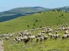
Living from the exploitation of forests and pastoralism, Altier had up to 1,500 inhabitants in the 19th century. There are only 220 left now, but vacationers continue to enjoy this green paradise ideal for hiking...
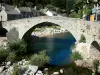
Several heritage sites are to be discovered in the vast commune. The most notable is the Château du Champ, built on a rocky promontory in a loop of the Altier, near the road arriving from Mende and heading towards the town. Three stories high and massive, it dates mainly from the 15th and 16th centuries when the feudal building was transformed into a more residential castle.
Sitting on a raised and fortified terrace accessible by stairs, the buildings are shaped like a horseshoe opening to the east.
The primitive keep constitutes the base of one of the right-angled wings of the house which is framed by several circular turrets at the corners or dividing the facade. One of them has a staircase. The keep has retained its walkway.
In the 19th century, the entrance having been transferred from one facade to another, the vestibule was built. The exterior chapel is also recent.
In the meantime, expansions had been made in the 17th century. However, the whole displays real unity and a typical character of the region, between fortress and Cévennes Renaissance (mullioned windows).
Still private, renovated (we admire its slate roofs in particular), the castle is listed in the Inventory and open to the public during Heritage Days in September. The rest of the year, its exteriors and its silhouette can be admired during a walk...
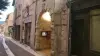
In the village, to see next, the Saint-Privat church whose nave and entrance door are in Romanesque style, date from the 12th century. The transept and the apse were added in the 14th or even 17th century, after the Wars of Religion which greatly affected the building. Once peace had returned, the bell tower-wall was in fact raised in the 17th century, a time when the single nave with a pointed barrel vault and the apse with a cul-de-four vault were remodeled.
Inside, restoration work during the last third of the 20th century restored its character to the church, where a decoration installed in the 19th century had stripped the cut stones, schist and sandstone rubble of their character. …
The Notre-Dame church in the hamlet of Habitarelle (in the east of the territory), the remains of the Grand Altier castle are finally worth mentioning.
Another walk is essential, around the town: this is the Sculpture Trail set up over 3 km by the association “Sculptures en Liberté”. Contemporary and monumental works (around twenty in total) are to be admired, which may surprise but fit perfectly into the natural setting and coexist harmoniously with the old buildings. Free access. Information on +33 4 66 46 90 59.
In terms of sports and leisure, note near the campsite bordering the river and which includes a reception dedicated to horseback hikers that there is a bowling alley and games for children.
Trout fishermen are also at the party: find out about the regulations at the town hall at +33 4 66 46 81 61.
However, these are definitely the hikers (on foot or on horseback, or even with a donkey as in the time of Stevenson, the famous novelist who toured the Cévennes in 1878) who are delighted by the potential accessible to the locality.
This is crossed by the GR 44 which links Les Vans to Champerboux (i.e. 93 km across the departments of Ardèche, Gard and Lozère) but also by the GR 68, which goes around the Mount Lozere. That is a potential of 115 km to be completed generally in six days via shepherds' paths and exceptional views between forests, cliffs and granite rocks...
More modest itineraries are also possible in the town itself. The opportunity to understand its sensitive areas but also to stop at producers who highlight the terroir: biscuit factory at Châtaigneraie in Combret (contact +33 4 66 46 20 67), jams at Ghislain Ruat in the village of Altier (contact +33 4 66 46 82 45) or Christian Vestit in the hamlet of Bergognon (information on +33 4 66 46 19 60) or the Sognes farm in Villespasses (dairy products and chestnut derivatives (call +33 6 30 08 50 22) and the Ferme des Moulins farm in Rochettes Basses (contact +33 4 66 46 91 65).
For hiking trails, maps and information at the tourist office on +33 4 66 46 87 30.
Finally, on the edge of the Cévennes National Park, it may be useful to find out about hikes, activities, exhibitions organized throughout the year on +33 4 66 49 53 00.